Spitzbergen - Arctic Coal Company |
Ships, Disasters, |
[Letter from Scott Turner to W. F. Bentinck-Smith, May 13, 1915, describing Turner's experience surviving the Lusitania disaster. Page 3.]
Scanned: May 5, 2008 |
|

Amy Turner (Prudden) |
Persons, Manners and Customs, Clothing and Dress, |
Amy, daughter of Mr. and Mrs. W. K. Prudden, of Lansing, Michigan, whose engagement to Mr. Scott Turner was recently announced. Ira L. Hill's Studio, New York.
Scanned: February 15, 2012 |
|

Spitzbergen - Arctic Coal Company |
Natural Resources, Mines and Mineral Resources, Geography, Maps, Harbors |
Map of Portion of East Shore of Green Harbour, West Spitsbergen. Showing Line of Proposed Tramway from Mine to Shore. Ayer and Longyear Tract No. 2. [A blueprint plan of an area adjacent Green Harbor showing a whaling station A/S Nimrod, a radio telegraph station, two coal mines and two houses.]
Scanned: April 21, 2008 |
|

Spitzbergen - Arctic Coal Company |
Harbors, Natural Resources, Mines and Mineral Resources, Geography, Maps |
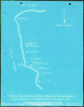
Sketch Map of Portion of East Shore of Green Harbor Showing Positions and Elevations of Some of Workings on Coal. Oct. 1913. 103. [A blueprint map of the east side of Green Harbor indicating the position and name of coal workings]
Scanned: May 5, 2008 |
|

Spitzbergen - Arctic Coal Company |
Natural Resources, Mines and Mineral Resources, Geography, Maps, |
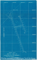
Mine No.2 Arctic Coal Co. Longyear City, Spitsbergen. [A blueprint map of a small coal mine with heights above ground level indicated]
Scanned: May 13, 2008 |
|

Spitzbergen - Arctic Coal Company |
Natural Resources, Mines and Mineral Resources, Geography, Maps, |
Mine No 1 Arctic Coal Co. Longyear City, Spitsbergen. [Blueprint plan of a coal mine.]
Scanned: June 24, 2008 |
|

Spitzbergen - Arctic Coal Company |
Natural Resources, Mines and Mineral Resources, Geography, Maps, |
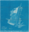
Vertical Section along Line "B.M. #3 - B.M. #9" [A profile view of coal seam #2 in relation to sea level and geological formations]
Scanned: May 14, 2008 |
|

Spitzbergen - Arctic Coal Company |
Railroads, Buildings and Structures, Geography, Maps, Harbors, Docks |
Arctic Coal Co,'s Loading Dock Advent Bay Spitsbergen. 90. [Plan of the end of a dock connected to three rail lines and an Bleichert aerial tramway. The topography of the seafloor is shown.]
Scanned: May 13, 2008 |
|

Spitzbergen - Arctic Coal Company |
Railroads, Buildings and Structures, Geography, Maps, Natural Resources, Mines and Mineral Resources |
Contour Map of Proposed New Stock-Yard. Arctic Coal Co. Longyear City. Spitsbergen. 88. [Plan showing the outline of a stockpile, the route of a Bleicherty Aerial Tramway, several rail lines and three warehouses.]
Scanned: May 14, 2008 |
|

Spitzbergen - Arctic Coal Company |
Harbors, Docks, Buildings, Natural Resources, Mines and Mineral Resources |
Topographic Map of Water Front Showing Dock, Gravity Incline, Ropeway Terminal, Stock-Yard and Tracks. Arctic Coal Co. Longyear City. Spitsbergen. [Plan of a small industrial complex by a dock with contour lines and water depths shown.]
Scanned: May 14, 2008 |
|