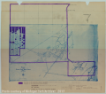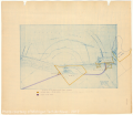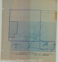
Map of the Centennial Copper Mining Company |
Earthwork, Industries, Natural Resources, Mines and Mineral Resources, Copper Mines and Mining |
[Map showing the property of the Centennial Minng Company and the property of the Calumet and Hecla Consolidated Copper Company, which was formerly the property of the Centennial Mining Company.]
Scanned: March 19, 2012 |
|

General Map of Mills along Torch Lake |
Historic Sites, Historic Districts, Manufacturing Process, Mills and Millwork, Metal Trade, Copper Industry and Trade, Copper Mines and Mining |
General Map of Mills Along Torch Lake, scale 1': 200". [Map shows the surface and mineral features of the mills of the mining companies situated on the shores of Torch Lake. The map also shows the stamp sands in relation to Torch Lake.]
Scanned: July 18, 2012 |
|

Map- Property of the Isle Royale Copper Company |
Historic Sites, Historic Mines, Metal Trade, Copper Industry and Trade, Copper Mines and Mining, Water, Lakes |
Map showing the property of the Isle Royal Copper Company. [Map key highlights the surface owned by the company, 57.84 Acres, and the Right of Way only. Attention is also paid to the stamp sands, and how they have extended into Portage Lake over the course of several years.]
Scanned: July 19, 2012 |
|

Map of the Centennial Copper Mining Company |
Earthwork, Industries, Natural Resources, Mines and Mineral Resources, Copper Mines and Mining |
[Map showing the land owned by the Centennial Mining Company, and surrounding land owned by different mining companies.]
Scanned: March 19, 2012 |
|

Ahmeek Mill |
Natural Resources, Mines and Mineral Resources, Copper Mines and Mining, Buildings, |
Property at mill, Ahmeek Mining Company. [Map showing location of the Ahmeek Mill on the shore of Torch Lake.]
Scanned: August 6, 2014 |
|

Calumet & Hecla Stamp Mills |
Natural Resources, Mines and Mineral Resources, Copper Mines and Mining, Buildings, |
C&H Stamp Mills and Houses, plan of buildings in 1914. [Map shows the Calumet Mill, the Hecla Mill, the boiler house, regrinding plants, the leaching plant and stamp sands all located on the banks of Torch Lake.]
Scanned: August 6, 2014 |
|

Mill Sites Along Torch Lake |
Natural Resources, Mines and Mineral Resources, Copper Mines and Mining, Buildings, |
Osceola, Lake No 2, Tamarack and Ahmeek Mill Sites.
Scanned: August 6, 2014 |
|

Cliff Dwelling |
Buildings, Dwellings, Housing, Single Family, Historic Sites, |
[Blue plans for a Cliff Mine two story single family home.]
Scanned: January 6, 2014 |
|

Cooper Home Drawing Plans - Cover Page |
Buildings, Dwellings, Housing, Single Family, , |
Working Drawings for a House for J. R. Cooper Esq. of the Quincy Mining Company in Hancock, Michigan. Charlton, Gilbert & Demar Architects Marquette, Michigan; Hancock, Michigan, Sault Sainte Marie, Michigan; Milwaukee, Wisconsin. [Other drawings for this house can be found under Map 62h-... call numbers.]
Scanned: February 11, 2014 |
|

Cooper Home Drawing Plans - East Elevation |
Buildings, Dwellings, Housing, Single Family, , |
East Elevation. Drawing No. 3733. [Home located in East Hancock. Building designed by Charlton, Gilbert and Demon Architects. Drawing shows the exterior plan for the East facing side of the Cooper House.]
Scanned: February 10, 2014 |
|