Quincy Boiler House #5 |
Buildings, Metal Trade, Copper Industry and Trade, Copper Mines and Mining, |
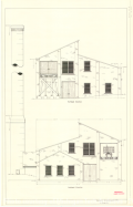
Exterior drawing of the Quincy boiler house #5 showing the northeast and southeast elevations.
Scanned: January 27, 2012 |
|

Plat of the Village of East Hancock |
Human Settlements, Cities and Towns, Buildings, Dwellings, Housing, Single Family, |
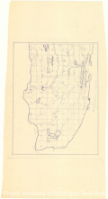
Plat of the Village of East Hancock. [Plat map of residential area in Hancock, Michigan. Shows yard lots and streats, along with annotations.]
Scanned: April 15, 2014 |
|

Administration Building 1st Floor |
Buildings, Education, Postsecondary Education, Education, Higher, |
Administration Building, First Floor, Scale 1/8 inch to 1 foot, Not to Scale. [Floor plan for the first floor of the Administration Building of the Michigan College of Mining and Technology. From Binder titled, "Photostat Prints - Floor Plans; Campus Buildings."]
Scanned: October 31, 2012 |
|

Administration Building 2nd Floor |
Buildings, Education, Postsecondary Education, Education, Higher, |
Administration, second floor, scale 1/8 in to 1 foot, not to scale. [Floor plan of the second floor of the Administration Building.]
Scanned: October 31, 2012 |
|

Library Additional Storage and Rifle Range |
Buildings, Education, Postsecondary Education, Education, Higher, |
Library Additional Storage and Rifle Range. Inside Demensions of Overhead Inclosed Bridge from the Administration Building to the Library Addition Building.
Scanned: October 31, 2012 |
|

Map - Cliff Mine |
Metal Trade, Copper Industry and Trade, Copper Mines and Mining, Geography, Maps, |
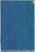
Map - Cliff Mine [Detailed Section]
Scanned: March 17, 2010 |
|

Geological Map |
Geography, Maps, , |
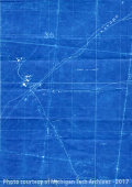
Geological Map, Northwest Portion of T57 N of R31 W. [Map includes Oscceola, Tamarack, Bammert Farm and Cliff.}
Scanned: September 21, 2012 |
|

Topographical and Underground Plan of the Cliff Mine |
Historic Sites, Natural Resources, Mines and Mineral Resources, Copper Mines and Mining, |
Traced May 17, 1928 for Geological Department, Calumet and Hecla Consolidated Copper Company, from lithograph accompanying Report of Charles T. Jackson, 1847.
Scanned: June 17, 2014 |
|

Plat Map- Copper Harbor |
Geography, Maps, , |
[Plat Map of Copper Harbor and end tip of the Keweenaw.]
Scanned: September 21, 2012 |
|

Map of White Pine Mine |
Industries, Natural Resources, Mines and Mineral Resources, Copper Mines and Mining, |
Map of White Pine Mine. [Underground map of White Pine Mine, showing the mining operations of the company by month.]
Scanned: February 25, 2014 |
|